


Erin Seitzler, tour guide at Lake Travis Zipline Adventures, has a birds eye view of the rising Lake Travis levels. Photo by Ellie
By LYNETTE HAALAND
Four Points News
Lake Travis rose more than seven feet from last week’s rains.
“The level of Lake Travis has risen about 7.5 feet in the last week. Lake Travis is now about 49% full (as of July 30),” said Clara Tuma, Lower Colorado River Authority public information officer.
On July 23 Lake Travis measured 635 feet mean sea level and by July 30 the levels were at 642 feet msl.
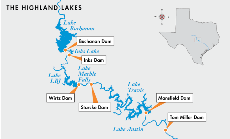
On July 24, LCRA opened floodgates at Wirtz and Starcke dams to move floodwaters that flowed into Lake LBJ from the Llano River downstream. The water flowed from Lake LBJ through floodgates at Wirtz Dam into Lake Marble Falls, and from Lake Marble Falls through floodgates at Starcke Dam into Lake Travis. The floodgates were closed the next day, Tuma shared.
“This was a classic flood event in Flash Flood Alley, as heavy rains fell in the watershed of the Highland Lakes and flowed down a tributary into the Highland Lakes,” Tuma explained. “We saw a similar event in April/May, when the area above Lake Buchanan received significant rains.”
Runoff from those rains significantly increased the level of Lake Buchanan, which now is 70% full. With the recent increase in the levels of Lake Travis, combined storage in lakes Buchanan and Travis, the two water supply reservoirs in the Highland Lakes, is now at 1.15 million acre-feet, or 58% full, Tuma said.
The Highland Lakes system, managed by the LCRA, consists of six dams and six lakes designed to manage water supply and flooding. Only Lake Buchanan and Lake Travis are designed to store floodwater, while the others, including Lake LBJ and Lake Marble Falls, are “passthrough” lakes.